![](/images/other/stat-length.png)
![Percorso Marcia La Bastide-Puylaurent - Randonnée de la Bastide Puylaurens à la Garde Guérin - Photo](https://media.geolcdn.com/t/1900/400/b3205bab-ddf0-4b99-ba12-c8f73b086d1e.jpg&format=pjpeg&maxdim=2)
Randonnée de la Bastide Puylaurens à la Garde Guérin
ajasse
Utente
![Lunghezza](/images/other/stat-length.png)
Lunghezza
20 km
![Altitudine massima](https://static1.geolcdn.com/siteimages/upload/files/1508320355ic_sort_altitude_max_24dp.png)
Altitudine massima
1141 m
![Dislivello positivo](https://static1.geolcdn.com/siteimages/upload/files/1508320355ic_sort_den_pos_24dp.png)
Dislivello positivo
443 m
![Km-Effort](/images/other/stat-length.png)
Km-Effort
26 km
![Altitudine minima](https://static1.geolcdn.com/siteimages/upload/files/1508320355ic_sort_altitude_min_24dp.png)
Altitudine minima
800 m
![Dislivello negativo](https://static1.geolcdn.com/siteimages/upload/files/1508320355ic_sort_den_neg_24dp.png)
Dislivello negativo
598 m
![Boucle](https://static1.geolcdn.com/siteimages/upload/files/16400158638029165_repeat_loop_refresh_sync_direction_icon.png)
Boucle
No
Data di creazione :
2019-06-03 08:00:45.229
Ultima modifica :
2019-06-04 08:51:11.296
![Marcia](https://static1.geolcdn.com/sitytour/trail-icons/101.png)
6h19
Difficoltà : Difficile
![Scannerizza questo codice QR per aprire il percorso nell'applicazione SityTrail](https://capi.geolives.com/qq0zvz2zws4bq2lad0pu/sitytour/trails/2104310/qr.png?size=200)
Applicazione GPS da escursionismo GRATUITA
Chi siamo
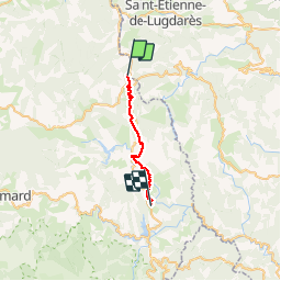
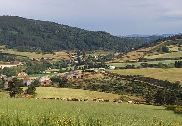
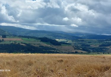
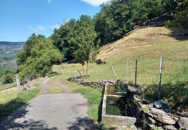
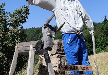
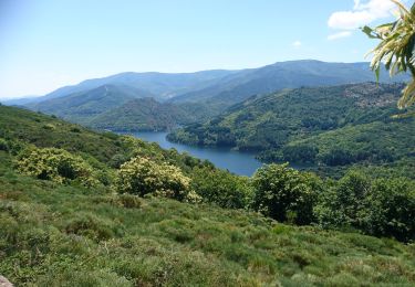
Percorso Marcia di 20 km da scoprire a Occitania, Lozère, La Bastide-Puylaurent. Questo percorso è proposto da ajasse.
Descrizione
départ de la Gare de la Bastide Puylaurent en direction de la Garde Guérin.
Petit détour par Prevencheres.
Ne pas manquer le belvédère à la Garde Guérin ainsi que l'a visite du village.
Localizzazione
Paese:
France
Regione :
Occitania
Dipartimento/Provincia :
Lozère
Comune :
La Bastide-Puylaurent
Località :
Unknown
Partenza:(Dec)
Partenza:(UTM)
571784 ; 4938198 (31T) N.
Commenti
Percorsi nelle vicinanze
![Percorso Marcia La Bastide-Puylaurent - la bastide saint Laurent _ Le Bleymard - Photo](https://media.geolcdn.com/t/375/260/ext.jpg?maxdim=2&url=https%3A%2F%2Fservices.sitytrail.com%2FGeolivesWS%2FDownloadMedia.ashx%3FTrailID%3D463471%26Media%3Dfix__20150818152203.jpg)
![Marcia Marcia](https://static1.geolcdn.com/sitytour/trail-icons/101.png)
la bastide saint Laurent _ Le Bleymard
Marcia
Difficile
(1)
La Bastide-Puylaurent,
Occitania,
Lozère,
France
![](/images/other/stat-length.png)
33 km | 46 km-effort
6h 59min
![](https://static1.geolcdn.com/siteimages/upload/files/16400158638029165_repeat_loop_refresh_sync_direction_icon.png)
No
![Percorso Marcia Mont Lozère et Goulet - Stevenson étape 7 - Photo](https://media.geolcdn.com/t/375/260/ca5e79f2-b988-472d-b1a4-865ced3314e1.jpg&format=jpg&maxdim=2)
![Marcia Marcia](https://static1.geolcdn.com/sitytour/trail-icons/101.png)
Stevenson étape 7
Marcia
Difficile
Mont Lozère et Goulet,
Occitania,
Lozère,
France
![](/images/other/stat-length.png)
20 km | 28 km-effort
4h 57min
![](https://static1.geolcdn.com/siteimages/upload/files/16400158638029165_repeat_loop_refresh_sync_direction_icon.png)
No
![Percorso Marcia Laveyrune - chemin de Stevenson étape 6 - Photo](https://media.geolcdn.com/t/375/260/03091446-e0a3-452d-a9a6-0e5da8b0e881.jpg&format=jpg&maxdim=2)
![Marcia Marcia](https://static1.geolcdn.com/sitytour/trail-icons/101.png)
chemin de Stevenson étape 6
Marcia
Difficile
Laveyrune,
Auvergne-Rhône-Alpes,
Ardèche,
France
![](/images/other/stat-length.png)
25 km | 34 km-effort
6h 50min
![](https://static1.geolcdn.com/siteimages/upload/files/16400158638029165_repeat_loop_refresh_sync_direction_icon.png)
No
![Percorso Marcia Mont Lozère et Goulet - Stevenson Chasseradès - Le Bleymard - Photo](https://media.geolcdn.com/t/375/260/084f4a90-f605-49e0-8cc1-95e8aee0296f.jpg&format=jpg&maxdim=2)
![Marcia Marcia](https://static1.geolcdn.com/sitytour/trail-icons/101.png)
Stevenson Chasseradès - Le Bleymard
Marcia
Molto difficile
Mont Lozère et Goulet,
Occitania,
Lozère,
France
![](/images/other/stat-length.png)
21 km | 29 km-effort
5h 4min
![](https://static1.geolcdn.com/siteimages/upload/files/16400158638029165_repeat_loop_refresh_sync_direction_icon.png)
No
![Percorso Marcia La Bastide-Puylaurent - Etape 5 Bastide Puy Laurent/ le Bleymard - Photo](https://media.geolcdn.com/t/375/260/11c1d804-2ed7-4698-a8c0-5175b4d6e991.jpg&format=jpg&maxdim=2)
![Marcia Marcia](https://static1.geolcdn.com/sitytour/trail-icons/101.png)
Etape 5 Bastide Puy Laurent/ le Bleymard
Marcia
Difficile
La Bastide-Puylaurent,
Occitania,
Lozère,
France
![](/images/other/stat-length.png)
30 km | 42 km-effort
7h 18min
![](https://static1.geolcdn.com/siteimages/upload/files/16400158638029165_repeat_loop_refresh_sync_direction_icon.png)
No
![Percorso Marcia Saint-Laurent-les-Bains-Laval-d'Aurelle - Laval d'aurelle Ubac - Photo](https://media.geolcdn.com/t/375/260/e0f1b595-b949-49f3-bae0-35874db96217.jpg&format=jpg&maxdim=2)
![Marcia Marcia](https://static1.geolcdn.com/sitytour/trail-icons/101.png)
Laval d'aurelle Ubac
Marcia
Medio
Saint-Laurent-les-Bains-Laval-d'Aurelle,
Auvergne-Rhône-Alpes,
Ardèche,
France
![](/images/other/stat-length.png)
7,6 km | 12,1 km-effort
2h 27min
![](https://static1.geolcdn.com/siteimages/upload/files/16400158638029165_repeat_loop_refresh_sync_direction_icon.png)
Sì
![Percorso Marcia La Bastide-Puylaurent - Chasséradès - Photo](https://media.geolcdn.com/t/375/260/99dcd61e-1413-422b-97ac-4dc748f0e62e.jpg&format=jpg&maxdim=2)
![Marcia Marcia](https://static1.geolcdn.com/sitytour/trail-icons/101.png)
Chasséradès
Marcia
Difficile
(1)
La Bastide-Puylaurent,
Occitania,
Lozère,
France
![](/images/other/stat-length.png)
12 km | 16,8 km-effort
8h 54min
![](https://static1.geolcdn.com/siteimages/upload/files/16400158638029165_repeat_loop_refresh_sync_direction_icon.png)
No
![Percorso Marcia Mont Lozère et Goulet - Chasserades Bleymard - Photo](https://media.geolcdn.com/t/375/260/116a16c1-813e-45da-b910-05ff52927fe4.jpg&format=jpg&maxdim=2)
![Marcia Marcia](https://static1.geolcdn.com/sitytour/trail-icons/101.png)
Chasserades Bleymard
Marcia
Difficile
Mont Lozère et Goulet,
Occitania,
Lozère,
France
![](/images/other/stat-length.png)
20 km | 28 km-effort
6h 57min
![](https://static1.geolcdn.com/siteimages/upload/files/16400158638029165_repeat_loop_refresh_sync_direction_icon.png)
No
![Percorso Marcia La Bastide-Puylaurent - de la bastide puylaurent à villefort gr700 - Photo](https://media.geolcdn.com/t/375/260/522da877-0139-4081-821c-3edc4b13e97a.jpg&format=jpg&maxdim=2)
![Marcia Marcia](https://static1.geolcdn.com/sitytour/trail-icons/101.png)
de la bastide puylaurent à villefort gr700
Marcia
Molto difficile
La Bastide-Puylaurent,
Occitania,
Lozère,
France
![](/images/other/stat-length.png)
25 km | 33 km-effort
7h 20min
![](https://static1.geolcdn.com/siteimages/upload/files/16400158638029165_repeat_loop_refresh_sync_direction_icon.png)
No